Allen & Zimmerman Nominated Finalists for the Piolet dʼOr
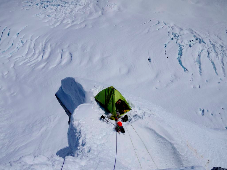
 AMGA Guide Mark Allen and his partner Graham Zimmerman were recently chosen as finalists from among 76 nominations for the renowned Piolet dʼOr, the most prestigious award in climbing. The winning team will be chosen by March 29, so stay tuned. In the meantime, we sat down with Allen to talk about the ascent that earned him recognition. Allen and Zimmerman did a first ascent of the remote Mt. Laurens (10,042’) in the Alaska Range. Because his narrative was chock full of interesting anecdotes, reflections, and helpful information that other guides may utilize for their own big trips, we’re posting it mostly as is, as it was relayed to us. Congratulations Mark and Graham, and best of luck!
 This story really started two years before our expedition (in 2011). Graham and I were preparing to climb the Infinite Spur of Mount Foraker (17,400’). We selected the zone west of Foraker in order to climb some other things to train for similar conditions and also acclimatize. We also really love exploratory climbing. So we tried to get Paul Roderick to land us close to one of our objectives, but he wouldn’t do it because it was too sketchy. We had to walk back to our warm-up climb, and we ended up focusing all our energy on that because it was just so challenging. We climbed the first ascent of a Voyager Peak (12,213’), and did three routes of mixed ice and rock. It was the most remote area either of us had ever been to in the Alaska Range… it was full questing into wild Alaska. And that’s where we discovered this obscure peak on the horizon [that would be Mt. Laurens].
What is that thing? We’d never heard of it before, so we photographed it from several angles at different times of the day. We really fell in love with it. It looked like a mask of a giant Wooly mammoth.
Graham brought the idea of climbing the peak up again sometime later, saying he was really pumped to go back. We knew we would be signing up for another big walking trip, but we started planning. We did a lot of research and couldn’t even find an elevation of the summit, as it hadn’t been surveyed. Dwarfed by Foraker, it hadn’t received much attention. We guestimated that it was over 10,000 feet, but we didn’t know how high it truly was. However, we did know that it had a 4000-foot face that we wanted to check out.
We sat down a lot with Paul to plan what side of the mountain we could land on, how much food we’d need, how long we’d have to walk. We went over the maps. We prepared ourselves for a 4.5-day journey. Paul ended up getting us about two days closer. The funny thing, when we pointed out our peak on the horizon as Paul was flying us out, he said, “Oh, you mean Mt. Laurens?” Paul had tried to climb it. He was in his late 30s at the time and had just bought his business, Talkeetna Air Taxi. He and an Austrian thoroughbred guide–Tomas Bubbendorf–had planned to climb the West Ridge of the peak, but apparently a large serac avalanche came down and dusted the plane not long after they established basecamp, and Paul ended up twisting his knee. He couldn’t climb, but his partner stayed and soloed a route that cannot be confirmed by Allen and Zimmerman at this time.
 After he dumped us off, it took us 2.5 days just to get to basecamp below the peak. We had to drag 100lbs of equipment each over the glacier’s ablation zone, both down and uphill. We invented a new sport–ghost riding–which was a bit like bowling; we hucked the sleds and let them go down the hill.
We did some recon, which is something we usually do before committing to a line. We tried to figure out: How does the mountain shed? Where are the objective hazards? Where are the seracs going to come down and kill us if we are underneath them? How many camps would we plan for? How would we get off? Where would we feel like we needed to get to every day to feel like we weren’t in danger? How much food did we need to bring? How much time do we think we have based on the diurnal trends? How does the sun work on the peak, and how does that affect the climbing?
We actually don’t like the sun when we’re climbing on a big snowy face. So we try to do as much climbing as we possibly can at night. Then we can stop and let the sun wash over us, warm us up while the mountain awakes and becomes active with serac fall, avalanches, and rock fall. We wanted to be out on a big ridge, a prow, or somewhere tucked away before that happened. Normally we bring a tent, which offers quite a bit of security and allows us to sack out for like six hours. With a tent, you only have to bring plus-30 sleeping bags. Then we hang out as long as we think we need to until the mountain features are glued back together.
There are a lot of things to figure out, and quickly. We had some really good high pressure, so we didn’t want to miss out. However, on our first attempt (on Mt. Laurens) we got totally crushed by really hard, steep climbing. We got to this corner where there was an aid seam capped by a mushroom, capped by another aid seem. I’m sure somebody could probably go through that, but I thought, this isn’t what I’m here for. It was too objectively dangerous. We got out of there. On our second attempt we found totally unprotectable garbage. We tried another variation, but found super rotten death flakes.
Because we had spent a week of time using up our wicked nice weather, we were concerned that we were running out of high pressure, so we decided we needed a distraction. We packed our bags for a five-day mission and headed to another peak in the area that was unclimbed. We ended up on a tiny saddle, and it started dumping snow for 3.5 days. We didn’t run out of food, but both our iPhones died. We were going crazy, counting squares on the nylon. It was supposed to be the trip of our dreams, but we weren’t having the best time.
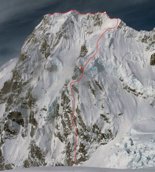
Ultimately, we reconsidered our objective. We decided to try another route on Mt. Laurens. We really had to fight our own egos to not climb the steepest, most technical line, but rather to find and really appreciate the peak for its aesthetic nature for what it was. We decided to climb something that we thought would be possible, but maybe not the hardest thing on the planet. We drew a line up the Northeast buttress, hit the ridge, and fell in love with the idea of cresting the ridge, and traveling across it. It wasn’t the plumb or cleanest line, but it was aesthetic and not contrived at all. Plus it was the only viable and safe way.
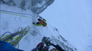
We went for it. The first pitch was the crux. It was really hard. Then the rest of the day was super pleasant, moderate water ice climbing, the type of stuff you target to find in the mountains. It was so fun and fast. We were having a great time! And it wasn’t dangerous. We were able to get to a really nice prow, where we bivied. The next day, we got into some unprotected snow climbing that was really steep, and we had to do some trickery to get out of that situation. We lost like three hours just trying to stay on the wall. But Graham found a cool variation, and we made it to the upper glacial plateau. After a break we headed up this really steep wind slab (about 40 degrees). I was pretty terrified, actually. We had to plow through with our hands just to walk through it, and it never really let up or became easy so that we could relax. But somehow we enjoyed ourselves… so many times on these mountains, you look around and know no one has ever been there before, and you just have this really cool perspective on the Alaska Range and the planet.
Eventually, we ended up on steep, firm snow, and simul-soloed 1000 feet to the ridge. We were mentally worked, but the day still had plenty of light, so we kept chugging. The ridges in Alaska are some of the cruxiest, and nothing prepares you for them other than climbing them. This ridge had massive cornices. We ended up having to tunnel underneath them. We went on both sides of the ridge. We used a new technique to protect ourselves, utilizing two ropes. We actually threw one over the cornices, and the other we let dangle on the steep side. Then we purposefully cut them into the cornices… We had to find creative ways to protect ourselves, which allowed us to continue. Otherwise we would have been paralyzed with fear because it was just unconsolidated steep climbing with no gear.
We bivied right on the crest of the ridge for five hours (2nd night). It was super exposed, and we had a great view. It seemed like a reasonable thing to do at the time. But we screwed up. When we resumed climbing, we switched aspects on the mountain; we transitioned from the east face to the west side of the ridge. The sun was still on the snowpack, and there was still free water in the snow (i.e. snow you can make a snowball with). We left the bivy too early and climbed for three or four hours in wet snow. We got totally soaked. We usually like the sun to go down and the darkness to arrive, but I was freezing when the sun went down. And then the wind came. It was only blowing like 25-30mph, but it felt like things were spiraling out of control. My hands were going numb a lot, and I wore all my clothes. We were looking at hours of darkness in the wind, and we didn’t know how to get down the mountain. I convinced Graham to stop, and we found a somewhat protected area, pitched the tent, and got in our bags. But the wind just taco’d our tent and folded on top of us. So we were wet, the inside of our tent was wet, and our bags were getting wet. We were really cold.
But we bivied until the sun came up. It was actually one of the best decisions I’ve ever made in the mountains. It was so easy to get to the top after that. But we didn’t have much time, as the weather was changing. I watched our descent completely fade into obscurity. In our summit photo that, my face shows how nervous I am. We were anxious to get out of there. So we figured out the elevation and then started the descent. It went really smoothly. We had planned well from the beginning and had a good memory for the terrain. We found a nice clean line, which we descended with all kinds of tricks and a lot of downclimbing (about half the feature). We got down and were completely blown away that we had done it!
How to describe the feeling? It was pure joy. It wasn’t our dream line, but it was hard, challenging, and exactly what we could handle. And it was really fun. Everything came to fruition—the whole two-year project, the failures, the recon ascents that didn’t work, dragging our sleds up there for two days… it just all worked out. It was a culmination of everything that I’ve learned in the mountains as a guide and a recreationist. I utilized all my skills in mountaineering, snow skiing, meteorology, ice climbing, and rock climbing, backcountry skills in general, glacier travel, expeditioniong… all those things came together It was the best representation of our skill sets. And it was really fun to have that all come together in a positive way and with my best climbing partner!
The route took us a total of 67 hours: 59 hours up and 8 hours down.
